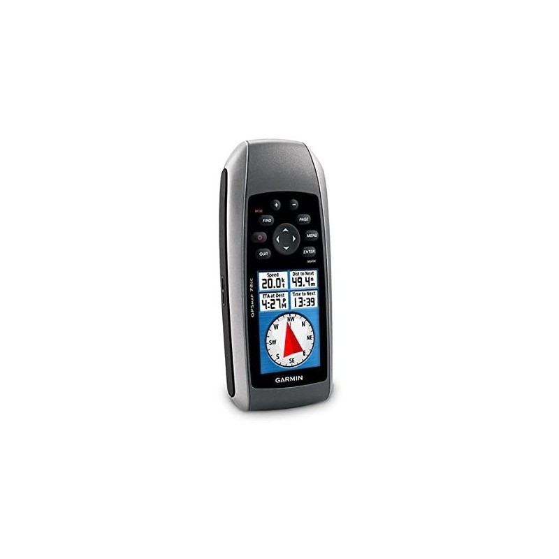

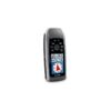
For boaters and watersports enthusiasts who want to run with the best, the rugged GPSMAP 78s features a 3-axis compass, barometric altimeter, crisp color mapping, high-sensitivity receiver, new molded rubber side grips, plus a microSD™ card slot for loading additional maps. And it floats!
Explore
GPSMAP 78s comes with built-in worldwide basemap, so you can navigate anywhere with ease. And, like the rest of the 78-series, 78s is water resistant (IPX7) and even floats in water.
Get Your Bearings
GPSMAP 78s has a built-in 3-axis tilt-compensated electronic compass, which shows your heading even when you’re standing still, without holding it level. Its barometric altimeter tracks changes in pressure to pinpoint your precise altitude, and you can even use it to plot barometric pressure over time, which can help you keep an eye on changing weather conditions.
Share Wirelessly
With GPSMAP 78s you can share your waypoints, tracks, routes and geocaches wirelessly other compatible device users. Now you can send the location of your favorite fishing spot to a friend to find. Sharing data is easy. Just press “send” to transfer your information to similar units.
Keep Your Fix
With its high-sensitivity, WAAS-enabled GPS receiver and HotFix™ satellite prediction, GPSMAP 78s locates your position quickly and precisely and maintains its GPS location even in heavy cover and deep canyons. The advantage is clear — whether you’re in deep woods or just near tall buildings and trees, you can count on GPSMAP 78s to help you find your way when you need it the most.
Add Maps
Adding more maps is easy with our wide array of detailed marine, topographic and road maps, available on microSD card. Conveniently plug in BlueChart® g2 preloaded cards for a great day on the water or City Navigator NT® map data for turn-by-turn routing on roads (see maps tab for compatible maps). The card slot is located inside the water resistant battery compartment, so you don’t have to worry about getting it wet. GPSMAP 78s also supports BirdsEye™ Satellite Imagery (subscription required), that lets you download satellite images to your device and integrate them with your maps. In addition, the 78s is compatible with Custom Maps, free software that transforms paper and electronic maps into downloadable maps for your device.
Get Connected
You’ve been busy exploring and now you want to store and analyze your activities. With a simple connection to your computer and to the Internet, you can get a detailed analysis of your activities and send tracks to your outdoor device using Garmin Connect™. This one-stop site offers an activity table and allows you to view your activities on a map using Google™ Earth. Explore other routes uploaded by millions of Garmin Connect users and share your experiences on Twitter® and Facebook®. Getting started is easy, so get out there, explore and share.
Find Fun
GPSMAP 78s supports geocaching GPX files for downloading geocaches and details straight to your unit. By going paperless, you’re not only helping the environment but also improving efficiency. GPSMAP 78s stores and displays key information, including location, terrain, difficulty, hints and descriptions, which means no more manually entering coordinates and paper printouts. Simply upload the GPX file to your unit and start hunting for caches. Slim and lightweight, 78s is the perfect companion for all your outdoor pursuits.
General
PHYSICAL DIMENSIONS
2.6″ x 6.0″ x 1.2″ (6.6 x 15.2 x 3.0 cm)
DISPLAY SIZE
1.43″ x 2.15″ (3.6 x 5.5 cm); 2.6″ diag (6.6 cm)
DISPLAY RESOLUTION
160 x 240 pixels
DISPLAY TYPE
transflective, 65-K color TFT
WEIGHT
7.7 oz (218.3 g) with batteries
BATTERY TYPE
2 AA batteries (not included); NiMH or Lithium recommended
BATTERY LIFE
20 hours
WATER RATING
IPX7
HIGH-SENSITIVITY RECEIVER
MEMORY/HISTORY
1.7 GB
Maps & Memory
ABILITY TO ADD MAPS
BASEMAP
AUTOMATIC ROUTING (TURN BY TURN ROUTING ON ROADS)
Yes (with optional mapping for detailed roads)
EXTERNAL MEMORY STORAGE
microSD™ card (not included)
WAYPOINTS/FAVORITES/LOCATIONS
2000
TRACK LOG
10,000 points, 200 saved tracks
ROUTES
200
Sensors
BAROMETRIC ALTIMETER
COMPASS
Yes (tilt-compensated 3-axis)
Outdoor Recreation
AREA CALCULATION
HUNT/FISH CALENDAR
SUN AND MOON INFORMATION
GEOCACHING-FRIENDLY
Yes (Paperless)
CUSTOM MAPS COMPATIBLE
PICTURE VIEWER
Reference Specific ReferencesCondition New product Andrew U07/01/2020Best product EverI sincerely recommend this company industries Safety Nigeria for any industrial and marine Equipment for personal and company needs, its the best in-terms of quality and reliable products. Write your reviewGarmin 010-00864-01 GPSMAP 78S Marine GPS NavigatorQuality12345Delivery12345Communication12345Pricing12345Title for your review*Your review*Required fields* Send or Cancel


Reviews
There are no reviews yet.